| |
|
Now
including an Addendum to the 2nd Edition with new sections on:
HD
radar and solid-state Technology
Working
with radar overlay on electronic charts
Integrating
AIS and MARPA for collision avoidance and situational awareness
Understanding
errors in radar overlay and MARPA
|
|
The
Radar Book--2nd Edition is used in training programs by;
United
States Power Squadrons Marine
Radar Seminar
Canadian
Power Squadrons
Royal
Canadian Marine Search and Rescue (RCM-SAR)
From the Introduction
Using a modern radar set, you can observe your surroundings in
daylight or darkness, through fog, snow and rain, 24 hours a day,
365 days a year.
Other navigation systems, such as GPS and Loran C interfaced
with chart plotters, will tell you immediately where you are in
relation to land and other permanent features, but they dont
tell you about transient phenomena, such as other boats, barges,
floating obstructions, etc. Radar is the only navigational
aid that not only helps you find out where you are, but shows you
where everyone else is too.
Using radar you can observe a dynamic, changing situation in
real time in zero visibility and darkness, yet navigate with
confidence and safety. In other words, having a radar set is
almost like having x-ray vision.
Yet many boaters find radar displays hard to interpret and,
consequently they fail to use their equipment anywhere near its
full potential. Of all the navigational aids available to the
recreational and small commercial boater, radar requires the most
interpretation in order to be used successfully; but once
mastered, radar is the most valuable of them all.
This book will help you understand how your radar works, so you
can properly control and interpret the information it provides, as
well as teach you the techniques for navigation, blind piloting,
and collision avoidance, so you can get absolutely the most
out of your set.
In The Radar BookEffective Navigation and
Collision Avoidance, Captain Kevin Monahan, presents the
complete picture on how to maximize the use of a marine radar system
for collision avoidance and navigation. Through the use of practical
examples, copious illustrations and actual radar images, the
newcomer to radar as well as the experienced mariner will learn how
to tune a radar system, interpret the display under real-life
conditions, and take advantage of all of the built-in features and
functions to use radar effectively as a real-time navigational tool.
The book also includes extensive discussions of todays next
generation radar systems, combining radar with electronic chart and
automatic target plotting technology, as well as tips and
recommendations for the purchase and installation of a new system.
Sample Images
 |
|
 |
|
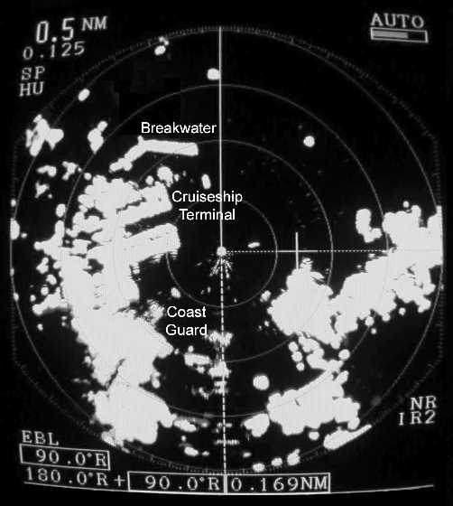
Using
the "anti-Rain Clutter" Control to Enhance Range Resolution
From
"The Radar Book" by Kevin Monahan |
|
Above
Left
In
the entrance to Victoria Harbour, the Ogden Point terminal
breakwater is ahead and to port. The terminal itself is directly to port.
The image is blurred and difficult to interpret. In addition, side lobe
echoes have cluttered the view of the channel astern.
On
exiting Victoria Harbour, the Ogden Point cruise ship terminal is abeam to
port. Note that even though the radar is operating on short pulse, the
images of the docks and warehouses lack definition and "side-lobe
echoes" and other interference have cluttered the view of the channel
astern.
|
|
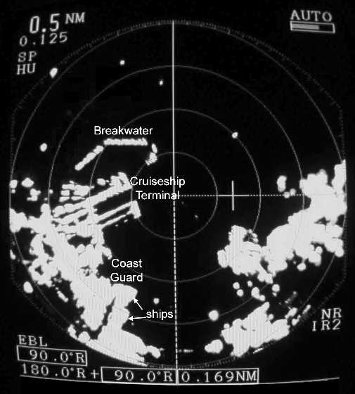
Above
Right
The
same location viewed with "anti-Rain Clutter" control
applied. In this image, the Ogden Point cruise ship terminal can be seen
much more clearly. The radar shows each dock as a discrete target. In
addition, two ships can be seen alongside the Coast Guard base at the
lower left. Targets on the display are clearer and more easily
identified.
By
using the "anti-Rain Clutter" control,
the operator has simulated the effect of using a short pulse length. Also, application of the "anti-Rain
Clutter" control has eliminated
unwanted "side-lobe" echoes
|
Table
of Contents
Acknowledgements
Introduction
CHAPTER 1 Tuning Your
Eye
The Searchlight
Principle
Ranges and Range Rings
The Look of the Display
Understanding the Radar Display
Sidebar: Heading Mark
Sidebar: Head-Up Relative Motion Displays
Sidebar: The Difference Between Course Made Good and Heading
Choosing the Appropriate Range Scale
Sidebar: A Tragedy
Identifying Radar Conspicuous Objects and Features
CHAPTER 2 Early
Successes
How to set up your
Radar
Estimating Position Using Range Rings
Sidebar: Using Paper Charts
Tip!!
Variable Range Marker
Finding Position Using the Variable Range Marker
Sidebar: Cocked Hat
Sidebar: Using Radar Conspicuous Points for Position Fixing
Sidebar: Proper Lookout
Constant Bearing / Decreasing Range means Collision Course
Sidebar: Extracts from the ColRegs
Electronic Bearing Line
Avoiding Collisions
Sidebar: Closest Point of Approach
Sidebar: Avoiding Action
Echo Trails
Caution
CHAPTER 3 The
Equipment
Radar Components
Scanner Unit
Sidebar: Frequencies
Scanner Installation
Display Unit
CRT Displays
LCD Displays
Pixels and Image Resolution
Sidebar: Analog Radars
Sidebar: Radar Safety
Controls
Knobs and Switches vs Menus and Soft Keys
Day and Night Displays
Sidebar: Reverse Colour
CHAPTER 4 Why Radar
Works
Basic Principles of
Radar
Principles of Reflectivity
Sidebar: Radar Reflectors
Microwave Pulses
Synchronisation of the Heading Flash
Sidebar: Analog Radars
Sidebar: Echo Strength
Radar Horizon
Transponders
RACON
CHAPTER 5 Controlling
and Interpreting the Display
Sidebar: Standard
Control Icons
Gain
Auto-Gain
Sidebar:AntiSea-Clutter Control (STC)
Sidebar: Persistence of Sea Clutter
AntiRain-Clutter Control (FTC)
Pulse-length Control
Using the Rain-Clutter Control to Enhance Range Resolution
Offset and Zoom
Dual Pulse Radar
How Beam Width Affects Bearing Resolution
Side Lobe Echoes
December 1, 2008Sectors and Ghosts
Multiple echoes
Overhead Cable Effect
Target Aspect
Interference
CHAPTER 6 Interfacing
Equipment and the Integrated Bridge
Head-up vs North-up
displays
Sidebar: GPS Heading Data
Sidebar: North-up, Course-up and Head-up Modes
Connecting Equipment Together
Sidebar: National Marine Electronics Association (NMEA) 0183
Managing Multiple Windows
On-Screen Waypoint Displays
Sidebar: Radar Waypoint Display
Sidebar: Active Waypoints and Course-up Display Mode
Interfacing Radar with Electronic Charts
Radar Overlay Equipment
Radar Sensor (Antenna) and Computer
Stand Alone Radar and Computer
Proprietary Systems
Electronic Chart Display and Information Systems (ECDIS)
CHAPTER 7 Further
Adventures in Navigation
Fixing Position using
the VRM (Review)
Sidebar: Taking VRM Measurements
Sidebar: Checking the accuracy of the VRM
Fixing Position Using the EBL
Sidebar: Radar Bearing Errors
Unstabilized Radar
Stabilized and Unstabilized Radars
Fixing Position Using a Mixture of Ranges and Bearings
One range and one bearing
Two ranges and one bearing
One range and two bearings
Mixing Sounder and Sonar Information
Using the EBL to Observe Transits
Navigation and Piloting
Sidebar: Practice and Consistency
Using Transits to Determine When to Turn
Maintaining Distance Off
CHAPTER 8 Further
Adventures in Blind Piloting
Parallel Indexing
Sidebar: Using an Offset EBL
Sidebar: Parallel Index Cursor
Setting up an Offset Transit
Sidebar: Using a Manual Parallel Index
Parallel IndexingNorth-up
Setting up a Parallel Index
Verifying the Position of a Buoy
Verifying the Position of a Buoywithout Offset EBL
Anchoring
Long Range Detection
Sidebar: Approaching a Narrow Entrance
Guard Zones
The Use of Radar Overlay in Navigation and Piloting
Sidebar: Situational Awareness
Sidebar: Offset Radar Images
Sidebar: North-up or Course-up?
Raster or Vector Charts?
Raster Charts
Vector Charts
Colours and Transparency
CHAPTER 9 Further
Adventures in Collision Avoidance
Steering and Sailing
Rules
Sidebar: Circumferential Distortion
Sidebar: Collision AvoidanceRestricted Visibility (Rule 19)
Sidebar: The Andrea Doria
Sidebar: Rule 8Action to Avoid Collision
Systematic Observation of Other Vessels
Sidebar: How close is too close?
Sidebar: A Eureka Bar Story
Head-up, Course-up or North-up?
Target Behaviour After an Alteration
Sidebar: Tugs at Nelson Island
Handling Multiple Targets
Switching Between Collision Avoidance and Navigation Modes
Simple Radar Plotting
Sidebar: Manual Radar Plotting
Automatic Radar Plotting Aid (ARPA)
ARPA Errors
Sidebar: ARPA Heading and Speed Input
ARPA in True Motion Mode
The Use of Collision Alarms for Offshore Sailors
The Use of Radar Overlay in Collision Avoidance
CHAPTER 10 Heavy
Weather
Scanner Height
Vessel Stability
Transmitted Power
Anti-Sea Clutter Control (STC)
Large Waves
Identifying Submerged Hazards
Breakers
Effective Use of Crew
Ice
Icebergs
CHAPTER 11 What Can Go
Wrong and What You Can Do About It
Failure Modes
Protecting Yourself
Dead Reckoning
Sidebar: Placing Too Much Reliance on the Radar
Radar Should be Your Primary Tool
Maintaining Situational Awareness
Sidebar: Am I Going Crazy?
Sidebar: Total Electrical Failure
Improving Your Own Visibility
Sidebar: Radar Reflectors Work
Human Error
Safe Speed
High Speed Operation
Raster Freeze
The Effect of Heavy Precipitation
Scanner Problems
Ice on the Scanner
Heading Flash Error
Obstructions to Scanner Rotation
Heading Input Error
Zeroing Error
PC Problems
Sidebar: Memory Overload
Radar Overlay Problems
Positioning Issues
Colour Issues
Appendix A Radar
Plotting
Simple Radar
Plotting
Manual Radar Plotting
Trial Manoeuvre
Appendix B Technical
Specifications
Bibliography
Glossary
Index
About the Author
|
What
readers say
In
straightforward, easy-to-follow steps, supplemented with copious
examples, this book takes the reader from the basics of radar to
advanced techniques. The new radar user will welcome this book, the
experienced user will appreciate it. Both will learn from it.
Robert
Hale
Former
Editor,
Waggoner Cruising Guide
This
is the most significant, easily understood publication regarding radar which
we've read in the past 24 years. It is a "must have" book.
Jack
and Linda Schreiber, MV Sanctuary
|
|